1.JPG)

.jpg)
1.jpg)
.jpg)

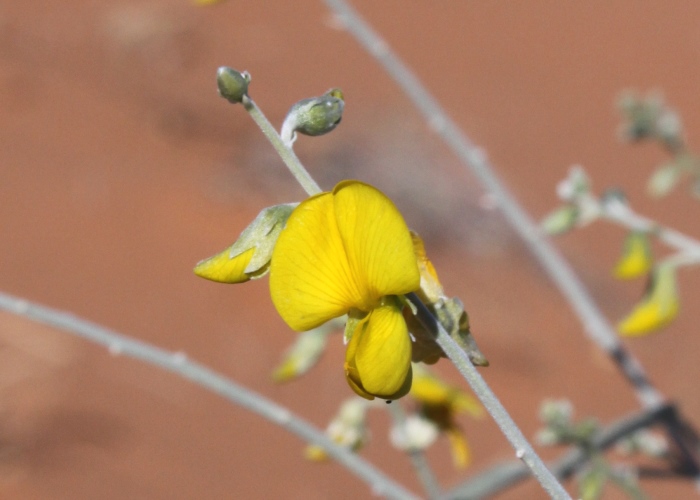
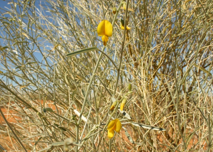
| Crotalaria eremaea subsp. eremaea | Crotalaria eremaea subsp. eremaea | |
1.JPG) |
 |
|
| Description:Plant | Description:Flower | |
| Location:Dune, Diamantina National Park, Western Queensland | Location: Dune, Diamantina National Park, Western Queensland | |
| GPS coordinates:23˚48.7475S, 141˚01.3491E | GPS coordinates:23˚48.7475S, 141˚01.3491E | |
| Date of photo:28 June 2009 | Date of photo:28 June 2009 | |
| Field No.:U165 | Field No.:U165 | |
| Crotalaria eremaea subsp. eremaea | Crotalaria eremaea subsp. eremaea | |
.jpg) |
1.jpg) |
|
| Description: Flower head | Description:Plant on top of dune | |
| Location:Dune, Birdsville Track, North East South Australia | Location:Dune, Birdsville Track, North East South Australia | |
| GPS coordinates:26˚24.995S, 139˚31.444E | GPS coordinates:26˚24.995S, 139˚31.444E | |
| Date of photo:6 August 2012 | Date of photo:6 August 2012 | |
| Field No.:1125 | Field No.:1125 | |
| Crotalaria eremaea subsp. eremaea | Crotalaria eremaea subsp. eremaea | |
.jpg) |
 |
|
| Description: Plant in habitat on dune top | Description:Flower and leaves | |
| Location:Dune, Birdsville Track, North East South Australia | Location:Dune, Diamantina National Park, Western Queensland | |
| GPS coordinates:26˚24.995S, 139˚31.444E | GPS coordinates:23˚48.7475S, 141˚01.3491E | |
| Date of photo:6 August 2012 | Date of photo:16 June 2007 | |
| Field No.:1125 | Field No.:U166 | |
| Crotalaria eremaea subsp. strehlowii (E.Pritz.) A.T.Lee | ||
| A subspecies from central Australia. This subspecies can have unifoliate or trifoliate leaves. | ||
| Crotalaria eremaea subsp. strehlowii | Crotalaria eremaea subsp. strehlowii | |
|
|
|
|
| Description:Flower | Description: Plant in habitat | |
| Location:Lasseter Highway, W of Uluru, Northern Territory | Location:Lasseter Highway, W of Uluru, Northern Territory | |
| GPS coordinates:25˚09.2150S, 132°27.0450E | GPS coordinates:25˚09.2150S, 132°27.0450E | |
| Date of photo:26 September 2018 | Date of photo:26 September 2018 | |
| Field No.:6744 | Field No.:6744 | |
| Crotalaria eremaea subsp. strehlowii | Crotalaria eremaea subsp. strehlowii | |
|
|
|
|
| Description:Leaf - unifoliate | Description:Leaf - underside | |
| Location:Lasseter Highway, W of Uluru, Northern Territory | Location:Lasseter Highway, W of Uluru, Northern Territory | |
| GPS coordinates:25˚09.2150S, 132°27.0450E | GPS coordinates:25˚09.2150S, 132°27.0450E | |
| Date of photo:26 September 2018 | Date of photo:26 September 2018 | |
| Field No.:6744 | Field No.:6744 | |
| Crotalaria eremaea subsp. strehlowii | Crotalaria eremaea subsp. strehlowii | |
|
|
|
|
| Description: Flower and buds | Description: Flowers and leaves | |
| Location:Lasseter Highway, W of Uluru, Northern Territory | Location:Lasseter Highway, W of Uluru, Northern Territory | |
| GPS coordinates:25˚09.2150S, 132°27.0450E | GPS coordinates:25˚09.2150S, 132°27.0450E | |
| Date of photo:26 September 2018 | Date of photo:26 September 2018 | |
| Field No.:6744 | Field No.:6744 | |
| Crotalaria eremaea subsp. strehlowii | Crotalaria eremaea subsp. strehlowii | |
|
|
|
|
| Description: Flower and buds | Description: Plant | |
| Location:Stuart Highway, Wauchope, Northern Territory | Location:Stuart Highway, Wauchope, Northern Territory | |
| GPS coordinates:21˚01.1840S, 134°11.4880E | GPS coordinates:21˚01.1840S, 134°11.4880E | |
| Date of photo:25 September 2018 | Date of photo:25 September 2018 | |
| Field No.:6740 | Field No.:6740 | |
| Crotalaria eremaea subsp. strehlowii | Crotalaria eremaea subsp. strehlowii | |
|
|
|
|
| Description: Leaf - trifoliate | Description: Leaf - underside | |
| Location:Stuart Highway, Wauchope, Northern Territory | Location:Stuart Highway, Wauchope, Northern Territory | |
| GPS coordinates:21˚01.1840S, 134°11.4880E | GPS coordinates:21˚01.1840S, 134°11.4880E | |
| Date of photo:25 September 2018 | Date of photo:25 September 2018 | |
| Field No.:6740 | Field No.:6740 | |
| Crotalaria eremaea subsp. strehlowii | Crotalaria eremaea subsp. strehlowii | |
|
|
|
|
| Description: Buds | Description: Plant in habitat | |
| Location:Stuart Highway, Wauchope, Northern Territory | Location:Stuart Highway, Wauchope, Northern Territory | |
| GPS coordinates:21˚01.1840S, 134°11.4880E | GPS coordinates:21˚01.1840S, 134°11.4880E | |
| Date of photo:25 September 2018 | Date of photo:25 September 2018 | |
| Field No.:6740 | Field No.:6740 | |
Image use policy 
This work is licensed under a
Creative Commons Attribution-Noncommercial 2.5 Australia License.
Page created 2 November 2011
Page edited 04 April 2019
© Roger Fryer and Jill Newland 2011 - 2019